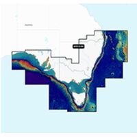


Platinum+ - Australia West Coastal - NPPC026R - Preloaded - Regular Coverage
Platinum+ - Australia West Coastal- NPPC026R - Preloaded - Regular Coverage - 010-C1359-40
Preloaded with Micro SD Card & SD Card Adaptor
Navionics Platinum+™ | NPPC026R | microSD™/SD™ and includes a One-year Chart Update FREE subscription.
The free subscription date starts from the day the chart is activated by the customer.
Previously comprised of Navionics+, Navionics+ Updates, Navionics Regions, Platinum+XL3 and Platinum+XL, the new
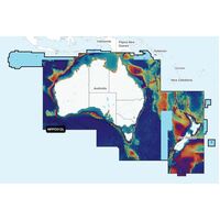
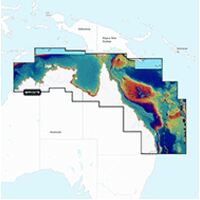
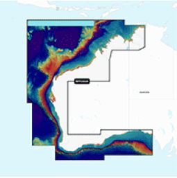
Coverage Area: Australia West Coastal Area - see coverage picture above.
This all-in-one max detailed cartography chart card for marine and lakes makes Navionics+ the perfect choice for cruising, fishing and sailing.
For offshore or inland waters, this all-in-one solution offers detail-rich integrated mapping, 0.5 metre HD contours, advanced features1 such as Dock-to-Dock route guidance technology1, and access to daily updates via the Navionics Chart Installer software.
Which Chart Card will Suit my GPS?
Download the above PDF Brochure which includes a GPS to Chart Card Compatibility Checker.
Alternatively, check the compatibility guide at www.navionics.com and note that these charts are not Garmin compatible.
Features:
Features of each chart product, including those exclusive to Navionics Platinum+ will remain the same, so users will still benefit from premium features like Relief Shading, Satellite imagery, 3-D view and Aerial photography for situational awareness.
- Satellite Overlay
- 3D View
- Panoramic Photos
- Nautical Chart
- Sonar Chart - innovative 0.5m bathymetry charts with extraordinary bottom contour detail
- Community Edits for local community information updates
- Daily Updates*
- Dock to Dock Auto Routing* (start your trip with a suggested route)
- Sonar Chart Live* (Create your own maps)
- Advanced Map Options* (customise your view)
- Plotter Sync* (Plan on mobile - go on plotter -transfer routes and markers)
- Sonar Chart Shading
Get the most accurate navigational data for your GPS plotter, an exclusive 0.5 m HD bathymetry map, and unique local content shared by Navionics app users. Navionics make thousands of edits every day, so you can always have the most current charts.
*Daily updates and advanced features (see link) are included for one year.
(992279)
Tips and Advice:
Most GPS chart plotters take the Micro MSD/SD card. The Micro SD card is supplied inside an outer SD card adapter - if you only need the MICRO SD card do not throw out the outer adapter SD case as it holds the serial number for future updates and warranty.
Note: Old plotters may not be compatible at all, or, you may need to go online and update their software, as they may not have the power to run today's modern cards which have much more detail and need more capacity and faster processing power.
Some chart plotters may need the Navionics compact flash cards which have been discontinued.
Make sure you check the GPS Compatability checker. (See PDF brochure on this website page).
Usually sent the same day - easily shipped Australia wide (by Toll or Express Post).
| SKU | 992279 |
| Model # | MSD/PLN50XG |
| Barcode # | 821245993199 |
| Brand | Navionics |
| Artist / Author | Ruth Cunningham |
| Shipping Weight | 0.1500kg |
| Shipping Width | 0.010m |
| Shipping Height | 0.010m |
| Shipping Length | 0.010m |
| Unit Of Measure | Each |
Be The First To Review This Product!
Help other Boat Gear Australia Pty Ltd users shop smarter by writing reviews for products you have purchased.